

DRONE PILOT & INSTRUCTOR
AUDIOVISUAL PRODUCTION, PHOTOGRAMMETRY, AND THERMOGRAPHY SERVICES.
PROFESSIONAL DRONE TRAINING
WHY REACH THE SKY ?
Thermography and photogrammetry are fields of imaging that allow for the remote measurement of temperatures and dimensions, respectively.
Thermography is useful in the fields of energy, industry, construction, and medical research for detecting heat problems, while photogrammetry is useful in the fields of mapping, 3D modeling, and building inspection for measuring distances, volumes, and shapes from aerial or ground-based photos.
The drone is a versatile tool to represent and enhance different types of projects, notably in the fields of video, photography, and cartography. In video, drones allow for spectacular aerial shots for cinematic productions, advertisements, news reporting, weddings, or sports events." in English.
In photography, drones allow for aerial shots in real estate, tourism, environmental sectors, as well as for structure inspections. In cartography, drones are used for the creation of 3D models of territories, analysis of disaster-stricken areas, crop surveillance, and the detection of environmental changes." in English.
TO BROADCAST
The drone is a powerful tool for disseminating information and content in various sectors. In event planning, drones allow for live streaming of videos on social media to increase the impact of events." in English.
In the real estate industry, drones allow for promotional videos to showcase properties in the best light. In the tourism industry, drones allow for promotional videos to highlight the tourist attractions of a region. In the agriculture industry, drones allow for the dissemination of data on crops to aid in decision-making and improvement of agricultural practices.
BECOMING A DRONE PILOT
LEISURE COURSE - OPEN CATEGORY
Leisure activity that can sell images.
I just bought a drone or I want to use a friend's drone.
I am flying on private land not controlled by an aerodrome and/or at least 150m from an agglomeration
THEORETICAL AND PRACTICAL COURSE
I want to become a professional drone pilot and be able to submit flight declarations to the competent authorities to fly in built-up areas or in restricted spaces.
Complete the practical training required by the Civil Aviation Authority with an approved operator. Acquire the necessary skills to manage a professional UAS operator activity, in Specific category, STS-01 and STS-02 (formerly S1, S2, S3).
To prepare for the Theoretical Aptitude Certificate for Drone Pilots (CATT) as a self-taught candidate using tools such as the Mermoz Drone Pilot Manual and Drone Exam. The registration fee for the exam is €30
BECOMING A PROFESSIONNAL DRONE PILOT
FAST COURSE / 2 DAYS
You must demonstrate a minimum level of drone piloting skills to be eligible for the fast-track training. This requires a minimum of 15 hours of flight experience on a drone.
Open to all people of an intermediate level to confirmed level. Maximum 2 people per session.
The pre-filled MANEX and personalized support.
NORMAL COURSE / 4 DAYS
You don't need to know how to fly, the training is designed for this purpose - to teach you how to become a drone pilot.
To obtain the necessary skills requested by the DGAC.
Open to all beginners. Maximum of 2 people per session.
The pre-filled MANEX and personalized support.
SKILLS AND LEGISLATION
Flying over airspace or over a property will require technical skills but also knowledge of the legislation.
I am registered as a professional drone pilot with the DGAC. I have mastered all the technical and safety aspects required for aerial photography. I am also an instructor to train you to become a professional.
Drone flight is subject to aviation rules, some of the safety principles of which must be known :
Maximum height: 120m (derogation possible)
Any overflight of anyone inside the shooting area is prohibited.
A safety perimeter must be established on the ground, necessary for take-off and in flight.
Any flight near an urban area or a group of people requires a prior declaration to the prefecture - at least 7 days before the flight.
Overflight or theft near certain sensitive sites (Hospital, airport, heliport, etc.) is prohibited or subject to authorization. Requests related to the use of airspace may be necessary.
The drone pilot is the only judge of the completion of a flight
Equipment
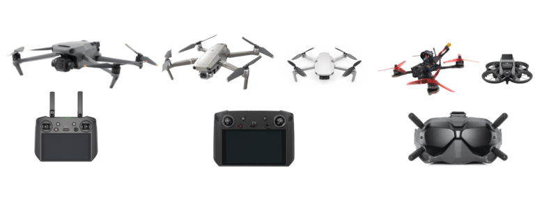
DRONER & FPV (First Person View)
Capturing high-quality images and videos using drones and First Person View (FPV) technology is an innovative way to produce content for various fields such as audiovisual production, marketing, tourism, real estate, and more.
Thanks to my expertise in drone and FPV (First Person View) photography, we are able to provide professional quality images and videos to meet your needs.Le drone FPV (First Person View) est un outil passionnant pour les amateurs de course de drones et de vidéos immersives.
In extreme sports, FPV drones allow for impressive point of view videos and an immersive flight experience. In drone competitions, FPV drones are used to create spectacular races where speed, agility, and precision are crucial. In video production, FPV drones enable dynamic and cinematic aerial shots for films, commercials, and music videos.
Finally, for technology enthusiasts, the FPV drone offers possibilities for customization, tuning, and optimization to improve performance and the flying experience.
INDEPENDENT TRAINER
As an independent drone instructor, I offer high-quality training for both beginner and advanced drone pilots. My objective is to train competent drone pilots who respect current regulations and are aware of best safety practices.
As a holder of an approved training organization, I can offer customized training to meet your specific needs. Whether you want to get into aerial photography, building inspection, or 3D mapping, I can provide you with the necessary training to achieve your goals.
I use a practical pedagogical approach to ensure that you acquire all the necessary skills to pilot a drone safely and efficiently. My training covers all aspects, from theory to practice, including flight preparation and execution.
By working with me, you can be assured of receiving quality training based on years of experience and a deep understanding of current regulations. Contact me today to learn more about my drone pilot training courses and how I can help you achieve your goals.
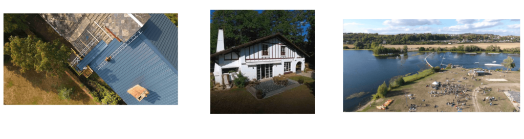
DRONE PHOTOGRAMMETRY
Aerial photogrammetry is an innovative technology that allows for capturing precise and detailed aerial images for use in many fields such as mapping, agriculture, construction, inspection, archaeology, and more.
Thanks to my expertise in drone photogrammetry, I am able to provide precise data and on-site information to meet your needs. I use the latest cutting-edge technologies to capture high-resolution aerial images and process this data to produce accurate 2D and 3D maps.
I am proud to provide innovative solutions for your drone photogrammetry projects. Contact me to discover how we can help you meet your drone photogrammetry needs.
DRONE THERMOGRAPHY
Aerial Thermography is an innovative technology that allows capturing aerial infrared images to detect temperature variations and anomalies in buildings, infrastructure, and equipment.
Thanks to my expertise in drone thermography, we are able to provide precise data and information to meet your needs in terms of preventive maintenance, leak detection, and building performance.
I use the latest cutting-edge technologies to capture high-resolution aerial infrared images and process this data to produce detailed reports and thermal maps.
Contact me to discover how we can assist you with your drone thermography needs.